
Blyth Relief Road - Public Consultation
Overview
The town of Blyth plays a key role in the regional economy, with the £70 million
‘Energising Blyth’ programme of investment aimed at making Blyth a thriving UK and international centre of renewable energy and advanced manufacturing. To ensure this economic growth becomes reality, it is essential that the links are in place to ensure the safe and efficient movement of people and goods.
To view a higher resolution, you can right click the image and select "Open image in new tab". Alternatively you can download the pdf by clicking here.
The Project
Northumberland County Council has been aware of traffic problems entering and leaving Blyth for several years. The two main roads into Blyth, the A193 Cowpen Road and A1061 Laverock Hall Road are heavily trafficked with over 20,000 vehicles a day on each road, and both suffer congestion during peak periods.
A highway solution for Blyth would provide capacity improvements within the area, making many of the emerging opportunities for development more achievable. It will provide more sustainable transport solutions alongside the road, with improved walking and cycling links and better access to the Northumberland Line railway stations. This will contribute to Northumberland achieving its 'Net Zero' vision by 2030 and make this local economic centre a more attractive place to live, visit and invest.
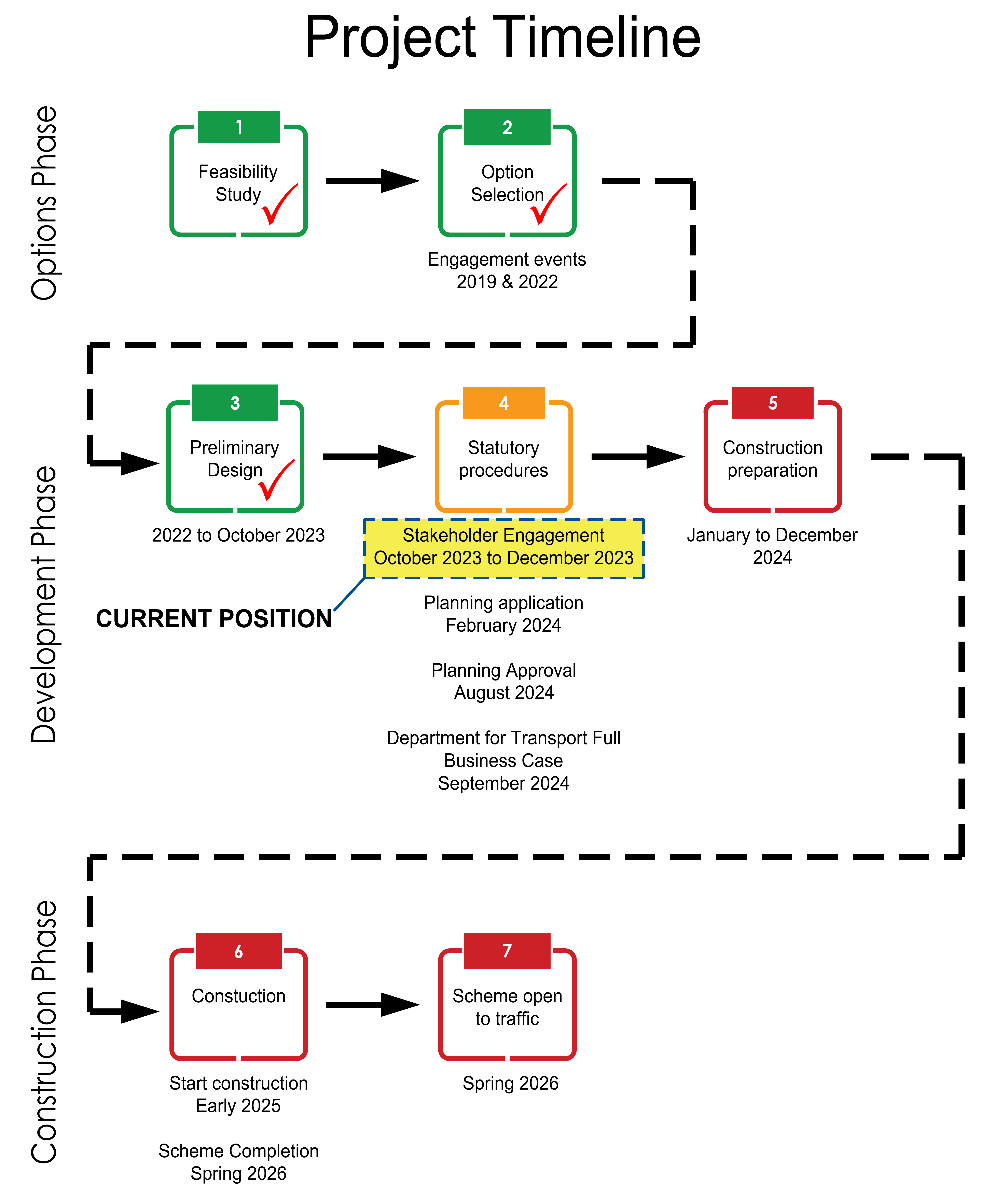
A Blyth Transport Appraisal was completed in 2015 and recommended several options to take forward to help relieve congestion. The report noted that longer term highway improvements would be required to add capacity to the network.
Several routes were investigated, and engagement took place in early 2019 to provide the community with details on all the route options. Public engagement in the summer of 2022 shared the route alignment (route 5) in its preliminary form to seek the views of the local community. This feedback has been taken on board and the current design reflects this where possible.
The Outline Business Case for the scheme, currently with the Department for Transport for review has been updated to reflect the preferred option and demonstrates that the following strategic objectives will be achieved by the scheme:
- Reduce congestion on the A193 Cowpen Road and A1061 Laverock Hall Road, resulting in journey time savings travelling into and out of Blyth;
- Improve bus journey time reliability through a reduction in traffic and delay on key corridors;
- Reduce road traffic accidents across Blyth through improvements to existing junctions and a reduction in the number of vehicles on key routes;
- Improve walking and cycling provision through new and enhanced facilities;
- Improve the living environment for residents through improvements in localised air quality.
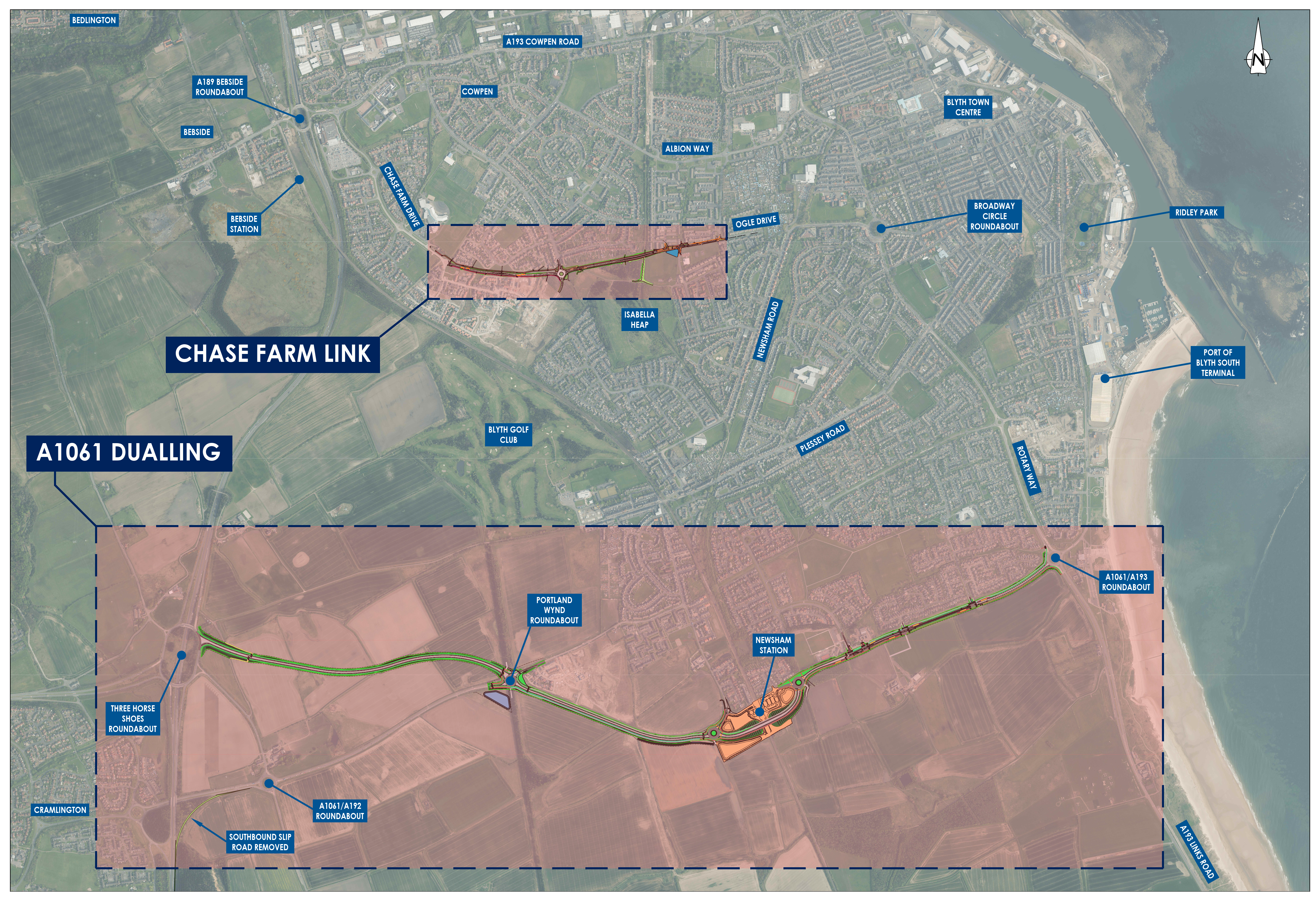
The Proposal
The scheme requires the upgrading of the existing A1061 Laverock Hall Road to provide a new 4.5km dual carriageway connection between the A189 Three Horseshoes roundabout to the A193/A1061 roundabout at South Beach. The scheme will also include a single carriageway connection between Chase Farm Drive and Ogle Drive to ensure benefits to the A193 Cowpen Road are maximised.
Key components of the scheme will include:
|
A1061 |
The roundabouts either side of the South Newsham Station rail line overbridge have been designed to accommodate the dual carriageway that will form Blyth Relief Road. The overbridge, being constructed as part of the South Newsham Station works, will become the eastbound traffic lanes whilst an additional bridge will be erected near this to provide a dual carriageway bridge arrangement for the westbound traffic flow. |
|
Chase Farm Link |
|
|
A1061 to A189 southbound merge slip road |
This will be closed to improve road safety on the A189. |
Environment
Throughout the project, lifecycle environmental impacts are to be given a high priority. Surveys are currently being undertaken to identify existing environmental conditions. The planning application for the scheme will include an Environmental Statement to assess all issues associated with the impact of the scheme and seek to minimise and mitiagte these impacts where possible.
Minimising carbon emissions during the construction and operation of the new relief road is a key priority for the scheme. Measures such as those outlined below will aim to minimise the carbon footprint of the scheme;
- Preparation of a Carbon Management Plan
- Re-using existing carriageway where possible
- Re-use of existing materials on site and use of sustainable and recycled
- construction materials where possible
- Provision of public transport facilities and cycling, walking & equestrian routes/links
Construction Phase
The construction phase is anticipated to take 16 months commencing early 2025 depending on the success of the funding bid.
A1061
A1061 Objective
The objective of the A1061 works is to improve journey times by reducing
congestion to the south of Blyth. The improved highway will tie in with the ongoing works which form part of the Northumberland Line project at
Newsham. The scheme proposal for a dual carriageway link from the A189
to the A193 provides a robust solution to the congestion on the A1061.
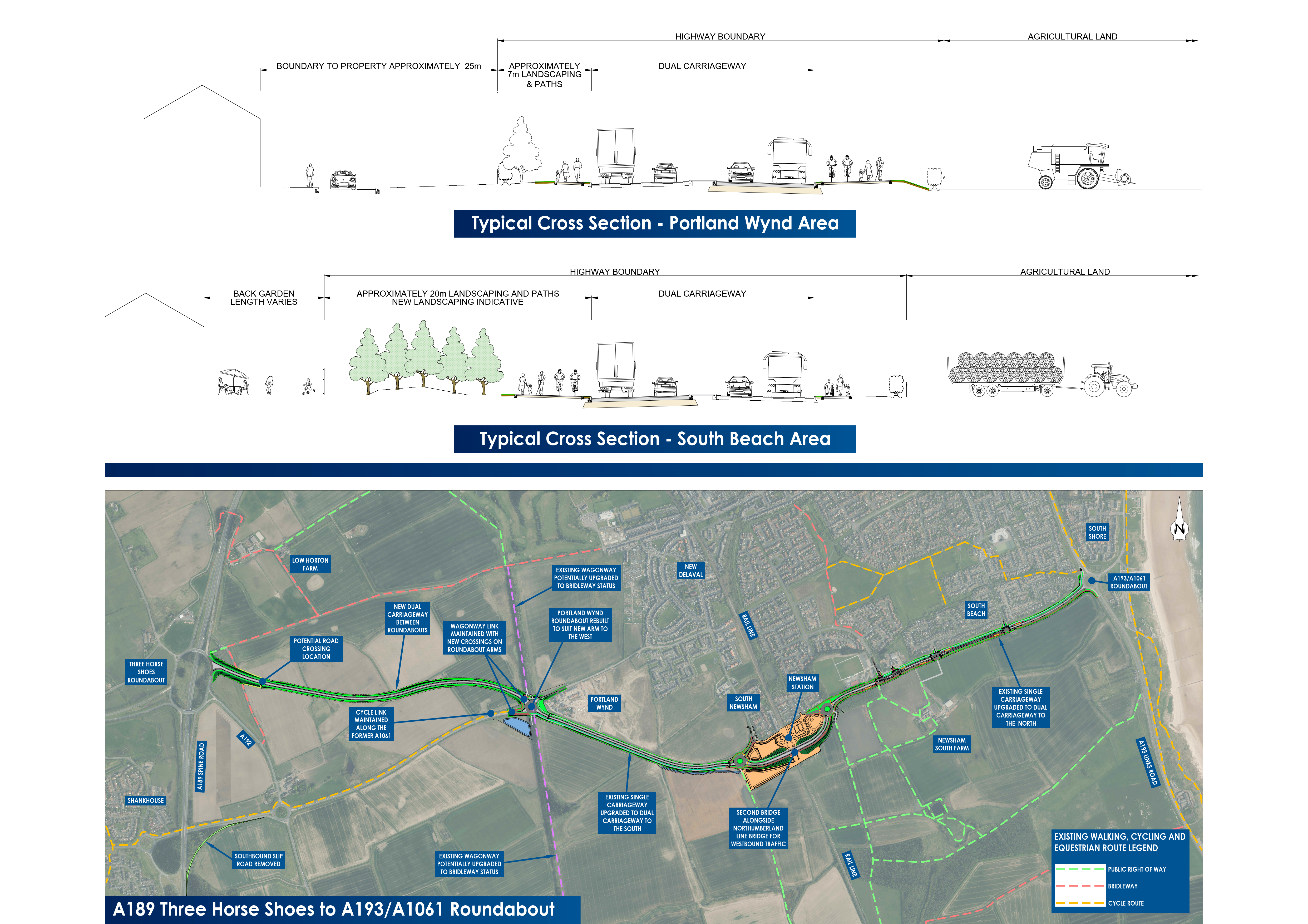
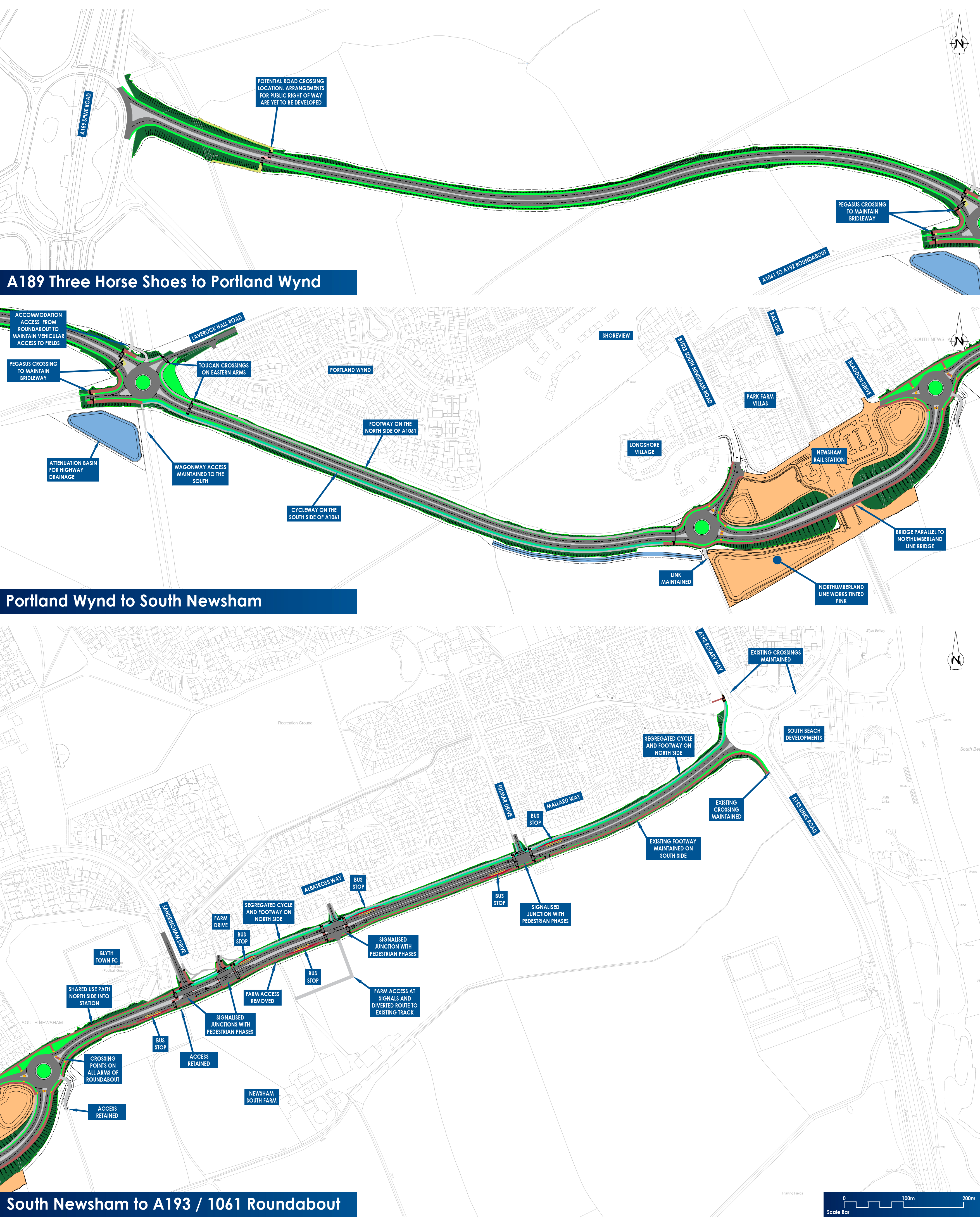
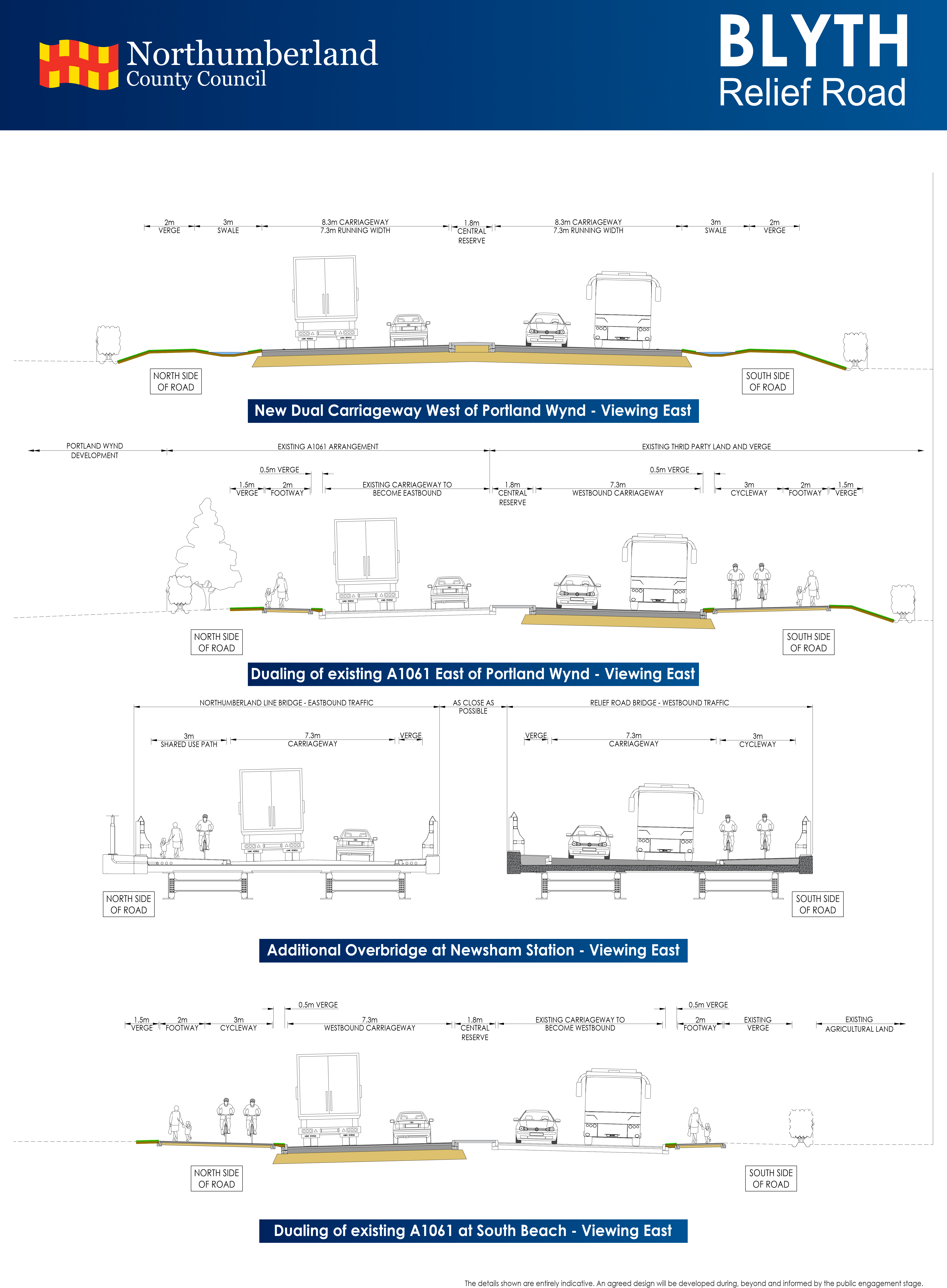
Road Layout
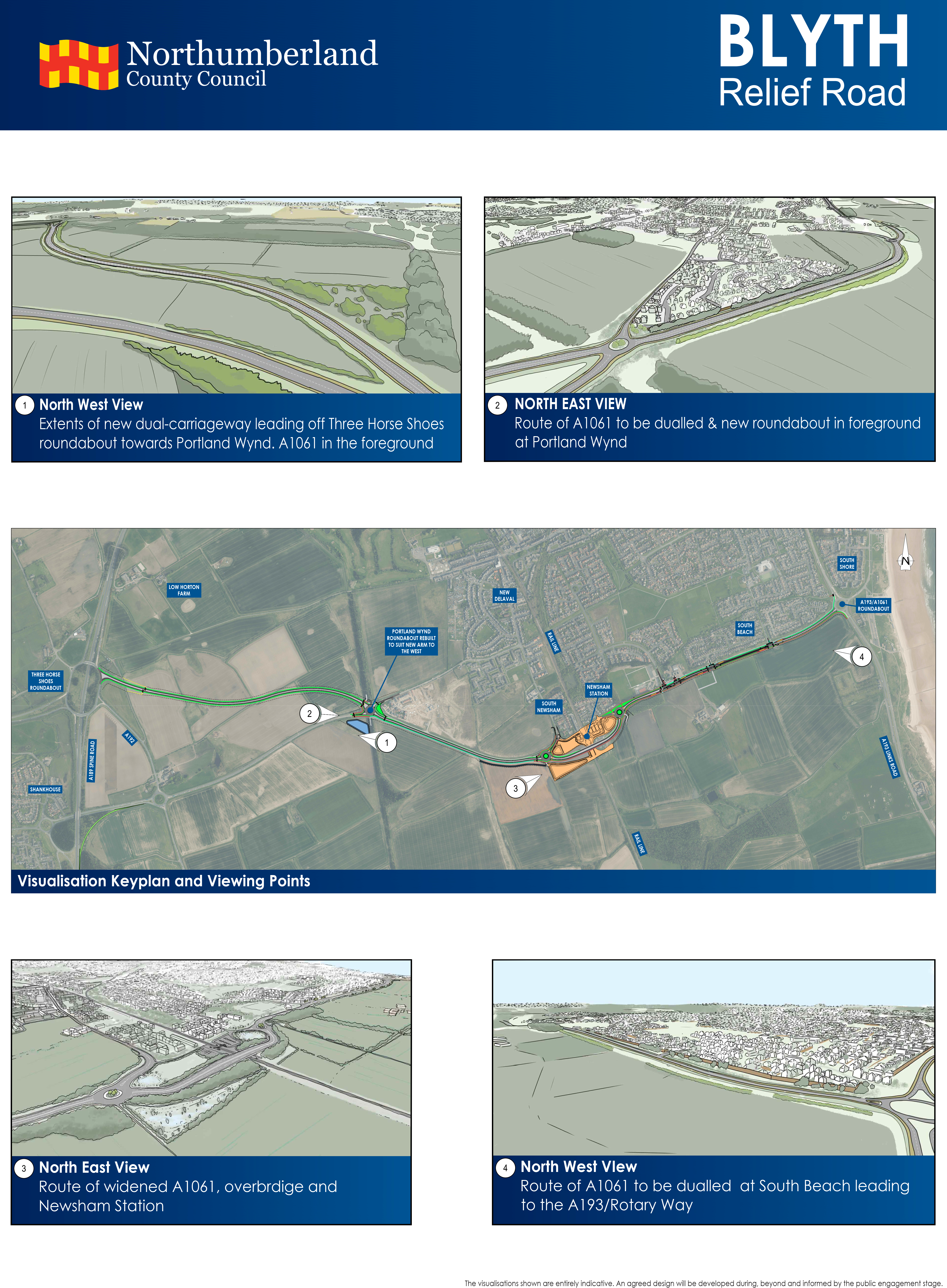
A dual carriageway will be created from The A189 Three Horse Shoes roundabout to the A193 South Beach roundabout. The section between the A189 and Portland Wynd roundabout will be completely new dual carriageway with a 50mph speed limit. From Portland Wynd roundabout to A193 South Beach roundabout an additional carriageway will be constructed alongside the existing road with a 40mph speed limit.
The existing roundabouts at the A189 Three Horse Shoes and A193 South Beach will be upgraded to accommodate the dual carriageway. The Portland Wynd roundabout will be rebuilt to suit the new alignment.
Existing junctions on the A1061 serving Sandringham Drive, Farm Drive, Albatross Way & Fulmar Drive will all be signal controlled.
A new overbridge will be constructed parallel with the bridge which forms part of the Northumberland Line rail project. The roundabouts that are being installed as part of the South Newsham Station works will be retained with minor alterations to accommodate the dual carriageway.
Along the new route several pedestrian, cycle and equestrian crossings are proposed which vary in their provision from uncontrolled crossings consisting of dropped kerbs and refuge islands to signal controlled Toucan and Pegasus crossings. Toucan crossings are for pedestrians and cyclists allowing cyclists to cross the road safely without needing to dismount. Pegasus crossings are for all users including equestrians and allow horse riders to cross the road safely without needing to dismount.
Land
The new road will require the acquisition of third-party land to accommodate the new road corridor.
- From the A189 to Portland Wynd, agricultural land will be required.
- From Portland Wynd to Newsham station roundabout the existing carriageway will be retained for Eastbound traffic. Agricultural land will be required to the south of the existing road.
- From Newsham station roundabout to the A193, the additional carriageway will be constructed on the south side of the existing A1061 to the area of Blyth Town Football Club before switching over to the north side to the A193 roundabout to avoid major public utility infrastructure.
Dualling of the A1061 between Newsham Station roundabouts including the new bridge will be accommodated in land already acquired as part of the Northumberland Line scheme.
Construction Phase
The construction phase is anticipated to take 16 months commencing in early 2025 until Spring 2026.
Construction will take place in several phases:
- Ground Investigation
- Site Clearance
- Enabling works and earthworks
- Drainage and formation level build up
- Highways surfacing and kerbs
- Street Lighting
- Landscaping
Throughout the construction process, impact upon the nearby properties will be minimised through early engagement and respectful working hours. Environmental control measures specified during the planning process will be implemented to reduce the environmental and social impact during construction.
A1061 Visualisations
A1061 Dualling Visual - Downloadable link
A1061 Detailed Visual - Downloadable link
A1061 Cross Section - Downloadable link
A1061 Visualisations - Downloadable link
Chase Farm Link
Chase Farm Link Objective
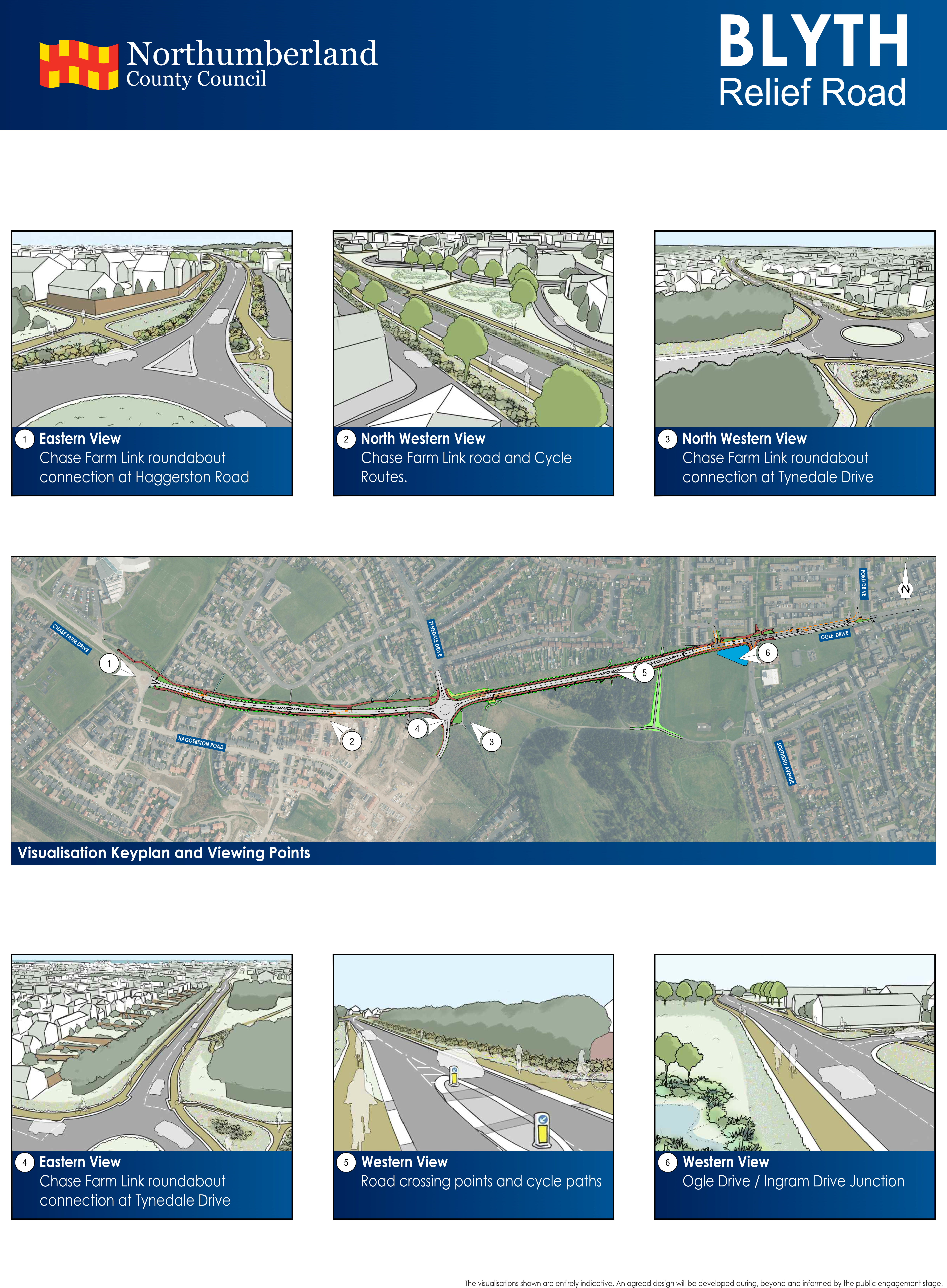
The link road between Chase Farm Drive and Ogle Drive, with a roundabout connection to Tynedale Drive, will alleviate traffic levels on the existing road network. It will provide options for road users travelling to and from the residential areas of Crofton Grange, Cowpen Farm and Cowpen resulting in reduced congestion on Chase Farm Drive and the A193 Cowpen Road. The proposed Chase Farm Link will connect currently disjointed housing developments and will provide a new through route connecting these developments to each other and Blyth town centre.
Road Layout
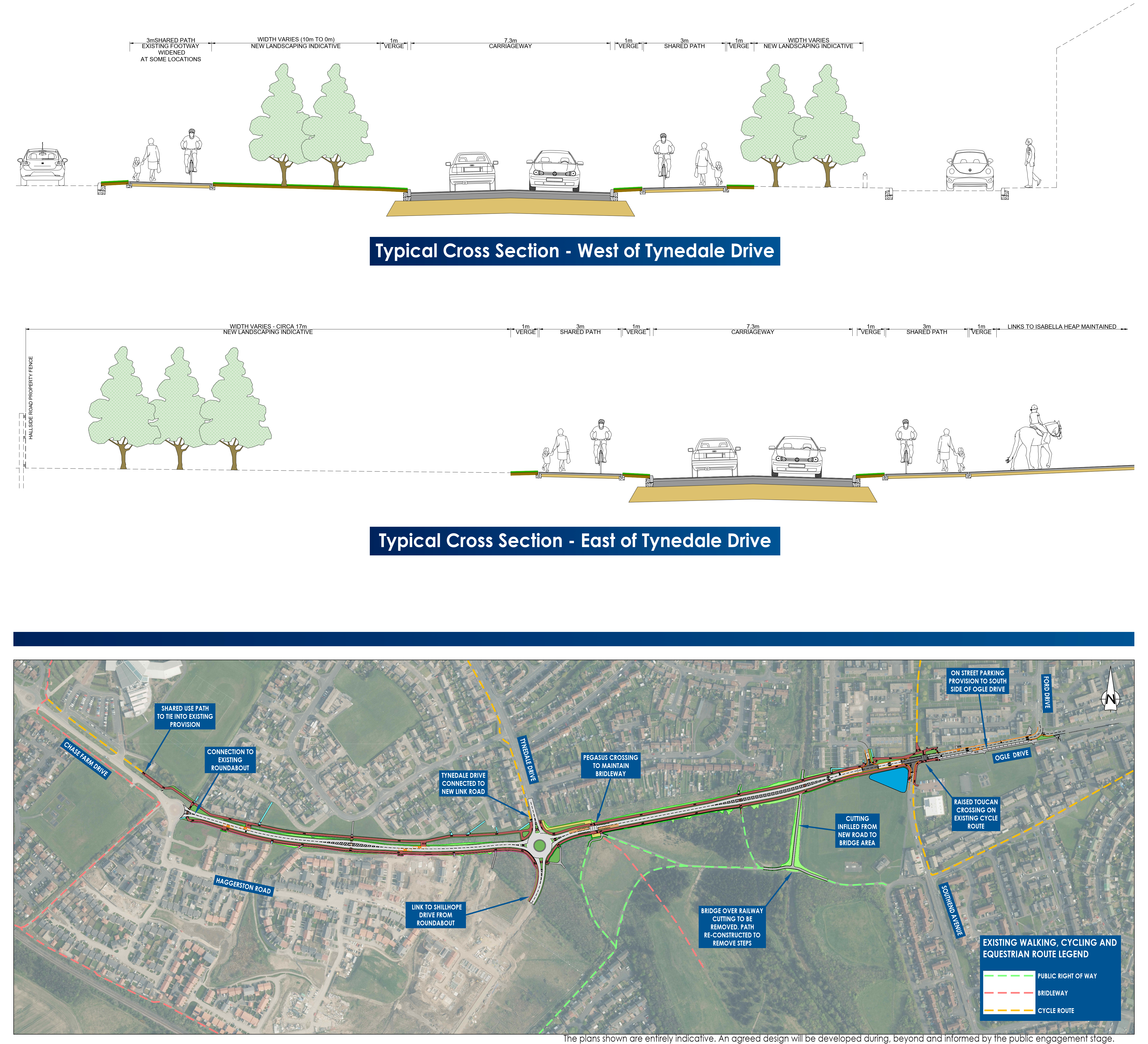
The road will comprise a street-lit single carriageway road with shared use cycling and walking facilities to both the North and South of the carriageway.
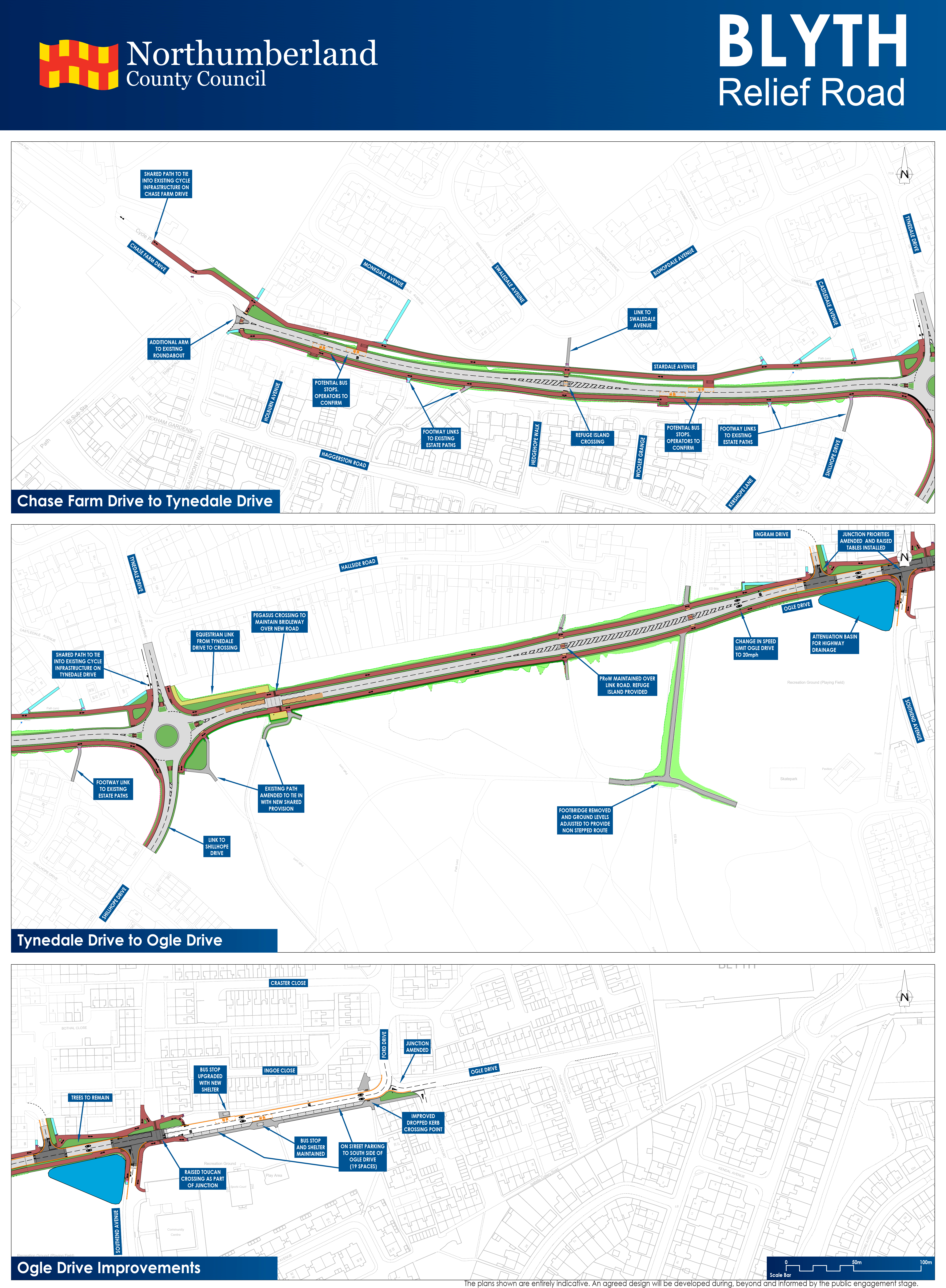
The existing roundabout at the West of the route will be amended to include an additional arm to the East which will connect to the existing stub end of carriageway at Ogle Drive.
Traffic priorities will be amended at both Ingram Drive and Southend Avenue with the primary traffic flow being East/West. These existing junctions will become simple T- junctions. At the South end of Tynedale Drive a new roundabout will be installed to connect to the new link road and to the estate to the South. Along the new route several pedestrian, cycle and equestrian crossings are proposed.
Speed Limit
The proposed speed limit for the link road will be 30mph between Chase Farm Drive and Ogle Drive.
Active Travel
The proposed scheme will help to encourage all forms of active travel via the provision of safe and fit for purpose cycling and pedestrian routes.
The new link road will allow for the connection of currently disjointed footways to the North side of the route to form a continuous link from Chase Farm Drive to Ogle Drive.
The existing footways within the Crofton Grange estate will be connected to the proposed link road path that will be provided on the South side of the link road.
The new East/West path to the South of the link road provides improved access to the existing infrastructure which is present on the Isabella Heap.
Land
The scheme proposes to construct the link road through a stretch of undeveloped land between the existing housing developments. The footprint will be kept to a minimum to reduce impact on the surrounding land. Landscaping improvements will take place along the route, with visual screening adjacent to properties, where appropriate.
Construction Phase
The link is proposed to be constructed between early 2025 and Spring 2026.
Throughout the construction process, impact upon the nearby properties will be minimised through early engagement and respectful working hours.
Environmental control measures specified during the planning process will be implemented to reduce the environmental and social impact during construction.
Chase Farm Link Visualisations
Chase Farm Link Visual and Cross Section - Downloadable link
Chase Farm Detailed Views - Downloable link
Chase Farm Link Visualisations - Downloadable link
Why your views matter
The consultation is an opportunity for you to have your say on the scheme that is being brought forward. We want to understand how local residents and businesses currently use the routes at present, any issues that exist. The insights provided will give us an understanding on how to shape the schemes to ensure that they cater for the needs of those living and working within the areas.
Public Consultation Events
We will be holding four public consultation events in November as part of a six-week consultation period. This consultation will begin on Monday 30 October and run until Monday 11 December 2023. During this time, we would like to gather your feedback on the Blyth Relief Road scheme.
Consultation events will be held on:
| Date | Location | Time |
|---|---|---|
| Thursday 2 November | Bede Academy, Sixth Avenue, Blyth, NE24 2SY | 16:00 - 19:30 |
| Friday 3 November | Bede Academy, Sixth Avenue, Blyth, NE24 2SY | 12:00 - 16:00 |
| Thursday 23 November | South Beach Residents Association, Blyth, NE24 3RJ | 16:00 - 19:30 |
| Saturday 25 November | South Beach Residents Association, Blyth, NE24 3RJ | 12:00 - 16:00 |
At the events, you will be able to speak with members of the project team, view the scheme proposals and submit your feedback.
Additional events
Following high interest in the consultation period and NCC’s commitment to community engagement, three additional public consultation events have been planned and will be held on:
| Date | Location | Time |
|---|---|---|
| Tuesday 28 November | Church of the Nazarene, Cramlington, NE23 1AA | 15:00 - 18:00 |
| Thursday 30 November | Hub at, Forum Way, Cramlington NE23 6YB | 17:00 - 19:30 |
| Monday 4 December | Isabella Centre, Ogle Drive, Blyth, NE24 5JF | 17:00 - 19:30 |
If you have a question about the scheme or would like to submit additional feedback, please use the email address below. If you would like a printed copy of the consultation information for the Blyth Relief Road scheme and a feedback survey, get in touch using the following contact details and we will post it out with a FREEPOST envelope.
- Email: blythreliefroad@mottmac.com
- Telephone: 0161 552 8016 (Between 9.00am and 5.00pm Monday to Friday)
- Post: FREEPOST NCC BRR Consultation
If you have further queries beyond the consultation, or need to request a hard copy of the information, please contact our dedicated mailbox: blythreliefroad@mottmac.com
What happens next
The Blyth Relief Road consultation period has now closed. Following the completion of the public consultation process, we will assess the feedback received for the scheme and review designs accordingly. Following that, the proposals will be developed further ahead of delivery. The project timeline is summarised below:
- Consultation completed on 11 December 2023
- Detailed design development to commence in mid-2024
- Construction is anticipated to begin in early 2025 until Spring 2026
Events
-
Bede Academy Event #1
From 2 Nov 2023 at 16:00 to 2 Nov 2023 at 19:30Bede Academy,
Sixth Avenue,
Blyth
NE24 2SY -
Bede Academy Event #2
From 3 Nov 2023 at 12:00 to 3 Nov 2023 at 16:00Bede Academy,
Sixth Avenue,
Blyth
NE24 2SY -
South Beach Residents Association Event #1
From 23 Nov 2023 at 16:00 to 23 Nov 2023 at 19:30South Beach Residents Association,
Blyth,
NE24 3RJ -
South Beach Residents Association Event #2
From 25 Nov 2023 at 12:00 to 25 Nov 2023 at 16:00South Beach Residents Association,
Blyth,
NE24 3RJ -
Nazarene Church Event
From 28 Nov 2023 at 15:00 to 28 Nov 2023 at 18:00Church of the Nazarene,
Cramlington,
NE23 1AA -
Hub at Forum Way Event
From 30 Nov 2023 at 17:00 to 30 Nov 2023 at 19:30Hub at Forum Way, (Library next to Concordia) (First Floor)
Manor Walks,
Cramlington
NE23 6YB -
Isabella Centre Event
From 4 Dec 2023 at 17:00 to 4 Dec 2023 at 19:30Isabella Centre,
Ogle Drive,
Blyth,
NE24 5JF
Audiences
- Anyone from any background
Interests
- Northumberland
Share
Share on Twitter Share on Facebook